Wild Waters
Water is, naturally, an element with a strong presence here in the rainforest at Reserva Las Tangaras. Whether rising as morning vapor misting up from the creek canyon, flowing in sheets across the broad yard a heavy downpour, or rushing down ever-incising channels to join other rivulets until they become something we might call a creek or river, water is everywhere. At least that’s how it’s been feeling this time of year, nearing the end of an “El Nin~o-year, Wet-Season.”
For sure, the rains have been strong and steady throughout the month of April, with occasional gloriously sunny mornings that give witness to transpiration in action: “steam” rising from plants into the atmosphere all around you. We closely monitor daily precipitation here at the Reserve, and roughly one-out-of-three days has dropped more than an inch of rain. A few days ago, we had a daily record for 2024, with over 4 inches (110cm) falling in less than 12hrs.

All this moisture, on these steep mountainous slopes, can wreak havoc on human logistics. The main road between Mindo and the capitol has been closed down several times due to mudslides, sometimes for hours, sometimes for days. Twice now, returning to Mindo on errands requiring visits to bigger towns, Anastasia and I have encountered stopped-dead traffic in both directions, and ultimately needed to disembark the bus, walk past a mile-long train of cars and trucks, encounter the mass of mud and rock spilled across the roadway, and join the intrepid others who, like ants, have mucked a pathway through the safest way to traverse the mudslide on foot. From there, it didn’t take too long to find a driver that was ready to give up on the wait, turn their vehicle around to give us a lift back to town.
On the Reserve, more rain means more trees coming crashing to the ground. On a recent phone call with my brother in northern California, he asked what causes all the tree fall. He lives in the pine forests of the Sierra Nevada and is accustomed to cleaning up downed timber, so the question came as one keen on the details of forest dynamics. In his California climate context, extended drought has weakened the conifers and they will fall from high cold winds snapping the weak and freezing trees half-way up the trunk. Or, a sudden downpour of rain in autumn will inundate the rootballs of trees on slopes that haven’t received a drop of water for half a year, and down they’ll tumble in a slurry of soil.
Here on the equator, treefall happens because of the optimal growing conditions for plant life, the steepness of the terrain, and all that water. Lightness and dark share the day equally—11 and half to 12 and a half hours of sunlight regardless of the month, although that sunlight is often dispersed by cloud cover. The temperature is (nearly) always somewhere between 60 and 80 degrees, day or night, January or June. Add water daily, in small or large doses from the ever-giving sky, and you’ve got ridiculous plant productivity. Trees can grow tall quickly, and many will readily play host to mosses and epiphytic plants that hold moisture and grow heavy.

In the dense forest, top-heavy trees will stretch out wide in the competition for sunlight until the slope of the terrain, the heft of the hangers-on—massive bromeliads out on branches, vertical carpets of orchids up the trunk, a tangle of fig vines dropping down the tree—the slow rot within the trunks, and soil saturation levels are all factors that conspire to topple trees almost daily in this environment. As a roadless Reserve, the extra water this month has kept us busy with clearing our all-important trails, which serve as the pathways for our guests’ enjoyment, access to our water source, the route to bird monitoring stations, and the way we re-visit with the outside world.
Indeed, water abounds on this landscape and—like this blog—eventually seeps or cascades down to its flowing purpose: the Nambillo River and two of her tributaries.
The Nambillo serves as a boundary to this fifty-hectare nature reserve, and two perennial creeks frame two other borders. (The fourth boundary line that closes the rectangular property is along the primary forest ridgetop, which drains this land.)
I have a strong affinity for flowing water, probably instilled from early childhood on the South Yuba River (in California) and deeply distilled during a career where I was known as “the river guy.” I worked with various organizations and social movements–employing a range of strategies, in river basins from California to Zimbabwe–all in service of the protection of free-flowing rivers, the biodiversity they support, and the ecological functions they play. So I can’t help but be interested in all manner of questions about the river that rushes below the front balcony of the lodge at Tangaras. Alas, limited bandwidth (meaning access to the internet, as well as available time for pet research projects) hasn’t allowed me to deeply investigate the Nambillo River, but I can share what I observe…and what you as a visitor can experience along the banks of our river and creeks.
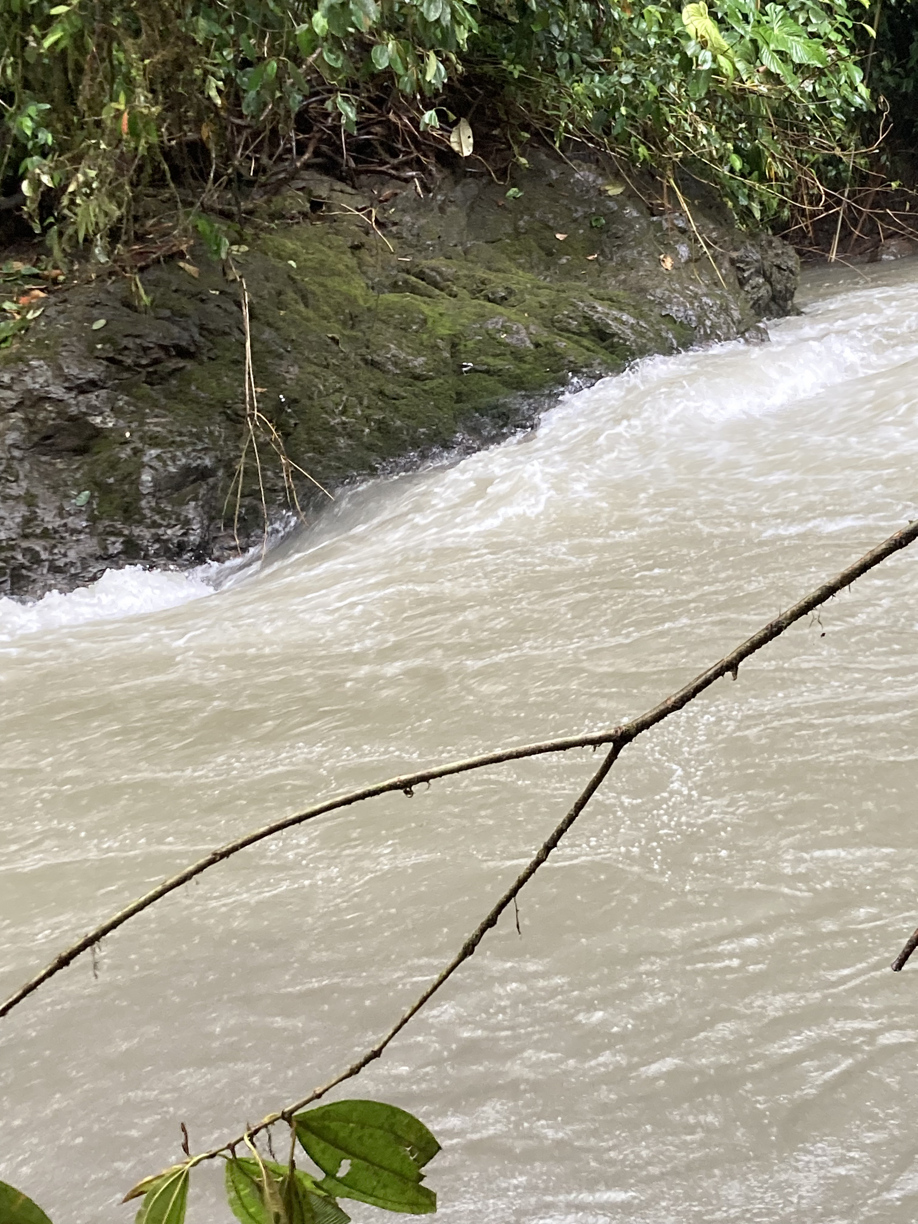
The Nambillo is what my fluvial geomorphologist friends might call a “flashy” river system. While I wish there was a flow gauge that monitored the changes of velocity and volume of the river, you don’t need a measurement to witness how dramatically the river rises during a rainstorm. Within an hour, a clear river of smooth riffles and runs can turn into a roiling brown torrent of jarring power–very exhilarating when crossing the footbridge! In really big storms, from the lodge we can hear, and feel in the floor boards, the river carrying large boulders thunderously downstream. The river flows through a very steep and deep gorge when it enters the Reserve property When the rains stop, give it a half-day and river velocity seems to drop by orders of magnitude, the deep brown turbidity clears, and one can almost feel tempted to wade into the shallows or take a dip in one of the several “pools” along our stretch of the Nambillo.
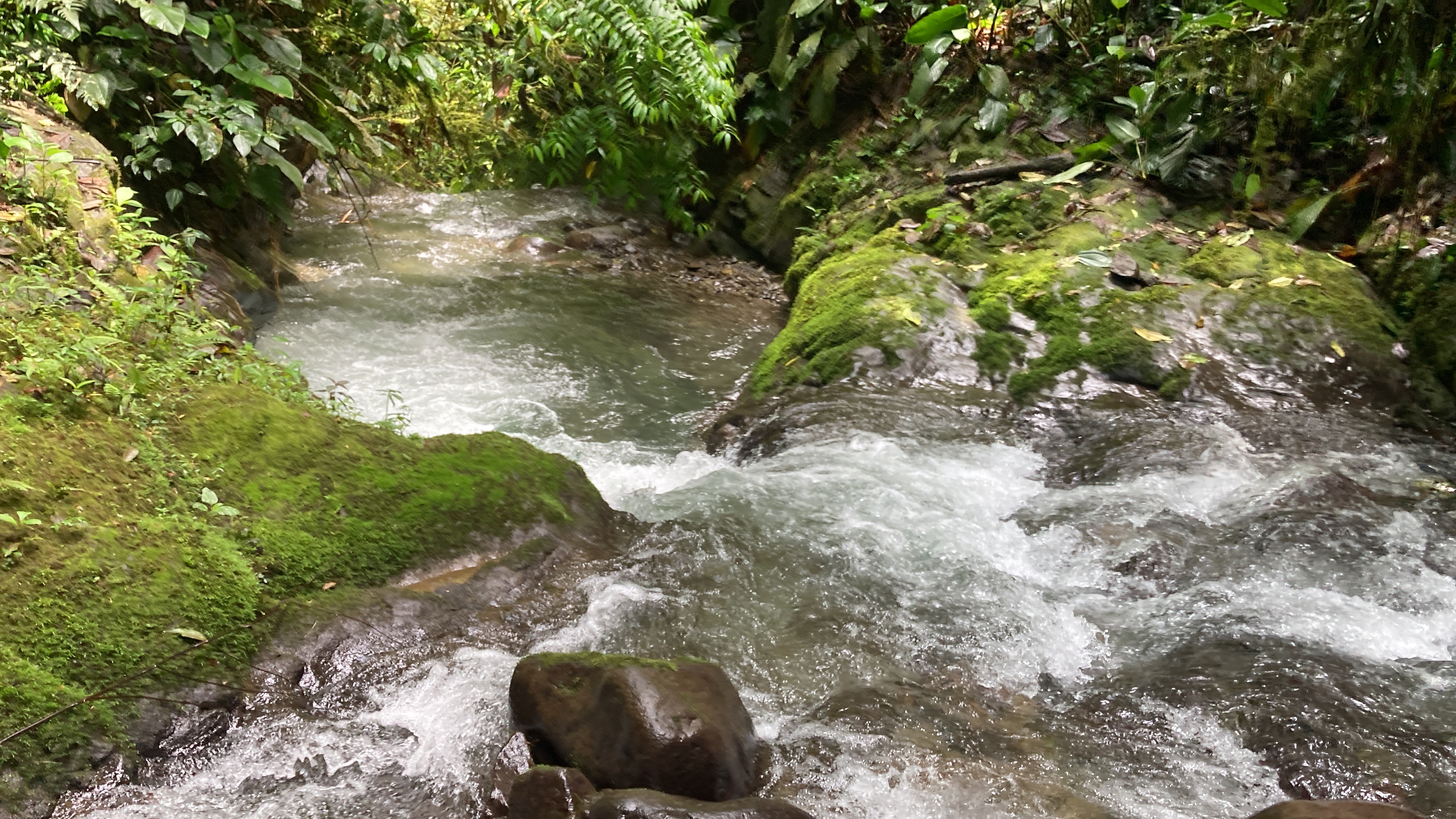
As for our two tributaries, one is the (locally) famed “Cascade Creek”. The series of waterfalls is popular not so much because of the great heights of the falls, but the pure beauty and clarity of the water and the azure swim holes that are formed in the plunge pools. As one of Mindo’s most popular attractions, 99.5% of visitors (I’d estimate) reach the “cascadas” by taking a cable car across the Nambillo and hiking down to the waterfalls. However, we share the waterfalls as a boundary line with our neighbors, and we are able to guide guests on a hiking tour to these cascades.
The other tributary, roughly on our eastern border, is very remote and generally inaccessible. We call it “Fountain Creek”, because it serves as the fount for our water source—crystal clear water that we pipe down to lodge. We have one trail (called Tres Tazas) that leads visitors to the creek’s confluence with the Nambillo, where our own private series of cascades and plunge pools cut through beautiful bedrock. The upper reaches of the creek are equally stunning. Because of the difficulty of reaching this area, and the sensitive of the area for our drinking supply, we only take our volunteers there on occasion. It’s spectacularly beautiful, and another reason to consider a longer stay at the Reserve as a Volunteer.

Finally, a word about the wildlife a visitor can encounter in the riparian zones—the unique forested river edges of the creeks and rivers. The birds are special: we regularly see Torrent Tyrannulet, Buff-tailed Warble, and White-capped Dipper (whose cousin, the American Dipper is a denizen of my home rivers in California). Rufous-gaped Hillstar and Green-fronted Lancebill are hummingbirds that clearly prefer the habitats along the Nambillo River and (at least at this time of year) we see them sallying from the handrail of our bridge. And my favorite reptile of the Reserve can also be seen basking on a warm boulder near the bridge—the Western Basilisk. This is the creature you might have seen on a nature documentary, in a slow-motion clip of a 2-foot-long lizard rising to its hind legs and running across the surface of the river (in my imagination, to the tune of the Violent Femmes song, “Jesus Walking on the Water”).
We also have many records of river otter plying the Nambillo, but we have yet to see one in our four months here. This sleek playful mammal is a bit of a totem-animal for me, so I’m confident we’ll spot one before our time at Reserva Las Tangaras conclude. Meanwhile, we keep our eyes on the river to discover the unexpected and wonderous. We invite you to join us and do the same. We’ll work to keep the trails clear for you, rain or shine!
Wild waters,
Jason (co-manager/volunteer steward)


Jason, I have so loved your writing! I’m coming this December for my second time at the reserve. Your educated naturalist “water guy” eyes has made me feel how much I missed in the mix of netting and birding and people time. Well, that is all good stuff… There’s so much more to notice. When I return I’d very much like to have your essays to refer to-opens my eyes, mind and heart. Thank you so much!! Shannon
LikeLike
Thanks for the kind words, Shannon. Yes, the Reserve is an inspiring place filled with “good stuff.” Too much to find the time to write about it all. Glad you’re planning to return later in the year!
LikeLike