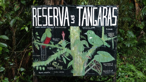
Walk on the Wildside
 If you’re not coming to Las Tangaras to see these guys (Andean Cocks-of-the-rock), you might be wondering what else the reserve has to offer. We’ll be the first to tell you, A LOT.
There’s birds, bugs, herps, orchids, bromeliads, ferns (tree ferns!), swimming holes, camping, colibres, mammiferos, fungi, and the list could endlessly go on if we don’t stop ourselves now.
You can enjoy ALL of the above listed things (and more) by taking a trip down one of Las Tangaras’ 10 hiking trails. Each trail is different in its own right, whether that be flora and fauna frequencies, elevation, difficulty, length, etc etc.
To give you a better understanding of the reserve and what wonders you can enjoy here, we’re gonna break down each trail for you and show ya some pictures, too!
Entrada Trail (Entrance):
Travel Time 45 minutes
Distance 2.0 km
Elevation minimum 1340 m – maximum 1515 m
This trail is the FIRST impression someone gets of Las Tangaras, but it’s misleading. Your initial vista views are of cleared farmland, which isn’t Las Tangaras at ALL. Since our reserve is located on the far side of the Nambillo river, you’ve gotta trek through other properties to get there. The trail cuts through farms and a patch of cloud forest owned by another reserve. Its status as a share trail (meaning it’s used by the owners of the farms and their mules) means this trail gets the most traffic and as such, gets the most muddy (especially in the rainy season). It’s best to wear boots on this trail and if its your first time ‘mud skiing’, be sure to take it slow.
As you make your way to the reserve, don’t forget to look up! On a clear day, the views of the forested mountains are spectacular and you might even see toucans flying along the canopy. Make sure to scan for mudslide scars. Brown scars are fresh (mud), green are old (new plants).
About 30 minutes into your walk on the Entrada trail, you’ll begin to notice a roaring sound growing ever louder. This is the Nambillo river and it is your final obstacle to get to the reserve. Don’t worry, we’ve made it easy by building and maintaining a hanging bridge.
As soon as you start hearing the river, you’ll begin your descent through a Club-winged Manakin Lek, an onslaught of Darwin Wallace Poison Frogs, and Crested Guan resting trees. The rushing river ruido (noise) means you’re close to the lodge.
Of all the trails, we are most familiar with this, simply because it is our lifeline to all things modern. It’s muddy, it’s grassy, and pock marked by mule prints, but at its end, after you catch wind of the Nambillo river and cross it to the reserve, it becomes cloud forest lushary.
Los Patos (ducks), Los Colibres (hummingbirds), y Tres Tazas (three cups):
Total Travel Time 25 Minutes
Total Distance 0.60 km
Elevation minimum 1335 m – maximum 1370 m
These three short trails join up to make one long trail, but each has its own characteristics.
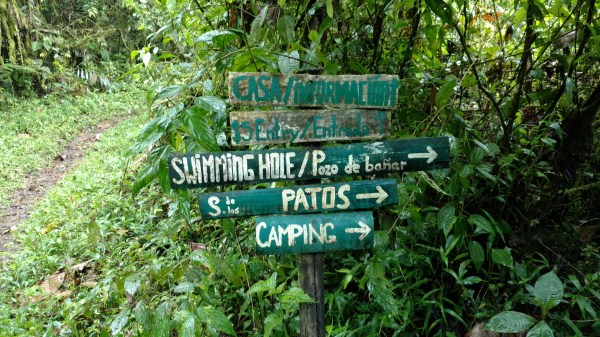
Los Patos: This is one of our easiest trails and we frequently suggest it to those looking for a quick jaunt through the reserve. It’s also one of our favorites to stroll after sunset as there’s plenty of Emerald Glass frogs to go around.
Los Patos is a low trail (by comparison), because it runs alongside the river. You are never out of range of its roaring and almost never out of sight of the river. It starts with a duck (pun not intended) under a fallen tree trunk covered in bromeliads, orchids, ferns, mosses, lichens, and bladderworts. Though they’re a pain to manage, fallen trees lend a sneak peak into the going ons of the canopy (orchid photos, mosses, etc).
At night, you can often hear Emerald Glassfrogs as they call to each other over the rush of the raging river. During the day, Darwin Wallace frogs are often heard and seen moving in and out of the leaf litter. There’s a camp site and a swimming hole (Playa de las Ranas aka Frog Beach). Depending on the river level, you can enjoy some great rock hunting at the beach, maybe see Basilisks basking and running on water, and find orchids in the trees along the trail.
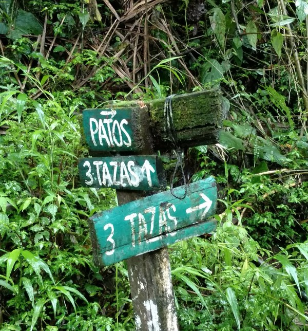
Tres Tazas: This trail is an offshoot from Los Patos. It dead ends at a stream that eventually meets the Nambillo River. At one point in time, it ended at a swimming hole, but the ever failing foliage has filled that area in. This trail doesn’t seem to be the most frequented, despite it’s proximity to one of our most often suggested trails, but it’s got a lot to offer. You must pass through one creek (now several creeks due to the amount of rain we’ve had…), duck under Angel Trumpet shrubs, watch out for Babbling torrenters, and look for hanging heliconia flowers.
As mentioned, a portion of the trail is in a shallow stream and much of it is muddy, so keep those rubber boots on while you search its subtle wonders.
Los Colibres: While the Los Patos and Tres Tazas trails are largely flat, the Colibres trail takes a sharp incline up to the elevation of the lodge, leading you away from the river. The staircase is beautiful and covered in the types of plants often found in hobbyists’ terrariums.
This trail is short and sweet, but it sheds a lot of light on the daily (nightly) going ons of the cloud forest. Animal tracks litter the trail. We’ve found evidence of Red-brocket Deer, Jaguarundi, Coatis, Agoutis, and white-faced possum on this trail. We think the animals like to use it to get to the river and given the amount of mud in the area, they usually leave a trail for us to follow.
Colibres ends at the lodge, bringing the LosPatos/TresTazas/Colibres loop to an end.
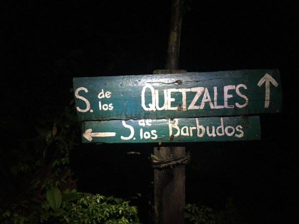
Quetzales Trail (Quetzals): Travel time 40 minutes
Total Distance 1 km
Elevation minimum 1330 m – maximum 1440 m
Quetzales trail is the “popular kid” of the reserve. It’s one of our most frequently suggested trails for tourists looking for a hike longer than 20 minutes.
Quetzales takes you up into the mountain and brings you back down again in a horseshoe. It features beautiful root staircases (courtesy of the trees), a variety of flora communities, canopy-level views (bird nerd alert!), several small streams you must cross (herp nerd alert!), and one small mudslide sight (Geo nerd alert!). It’s here, as you climb over the wide trunk to continue your hike, that you really begin to understand the ins and outs of the cloud forest.
The Quetzales represents both the light and dark side of the cloud forest. It’s the perfect trail for all hiking skill levels and takes up just the right amount of time to get you back to town again before nightfall.
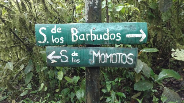
Barbudos Trail (Bearded): Total Travel Time 20 Minutes
Total Distance 0.4 km
Elevation minimum 1350 m – maximum 1470 m
Barbudos is a “stepping stone” trail. As in, you must use it to connect to other trails. It’s entirely up hill (one way, at least) and connects hikers to the Bosque and Tucanes trails.
Barbudos is incredibly different from any other trail on the reserve. It’s canopy-less and made of clay, which does make it a tad bit slippery, despite the amazing staircases built by previous managers. Given the lack of shade, there are gads of colonizing shrubs taking over the area and plenty of sun-loving organisms (i.e. bugs) to gaze at. (Seriously, though, if you haven’t taken the time to look at the bugs in the cloud forest, you are really missing out.)
Though it’s a lot of work in a short amount of time, the view from the top and halfway points of the Barbudos trail are simply lovely, even if the clouds are sitting low (typically happening). One can almost always appreciate the cloud forest for its cloud-covered mountains here and we’ve even been fortunate enough to see a rainbow. It’s also where the sun first hits the trees early in the morning, meaning lots of tanagers to look at (just as colorful as the bugs).
We don’t typically suggest this trail on its own, it’s a package deal. And if you’re going on an ACOR tour, you gotta put up with it, because it’s your ticket to the Bosque trail.

Bosque Trail (Forest): Travel Time 2 hour
Total Distance 1.4 km
Elevation minimum 1470 m – maximum 1800 m
The Bosque trail is like the kindly, wise old woman that lives a few doors down from you, but don’t you EVER cross her, because she can be a real tough lady.
The Bosque features lots of primary growth forest (you can find it on other trails, but this is the best place to experience it). It is laden with laenas, bromeliads, orchids, mosses, fungus, lichen, etc which, simply put, means it’s really stinking green, like a forest wonderland. It is always, ALWAYS wet because it is pretty much always in the clouds. The higher you climb, the more frequent the drops, even if it isn’t raining.
The Bosque dead ends at a clearing through which you *COULD* see a view of the surrounding mountains if it weren’t for the clouds. We’ve yet to enjoy that experience…
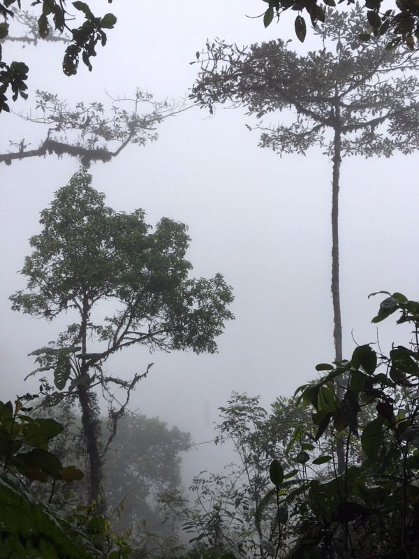
But, lower on the trail, we do sometimes get lucky enough to see the views. And if you’re willing, it’s a great place to enjoy the sunset on a clear evening.


The Bosque trail is best known for the ACOR lek (Andean Cock of the Rock mating site). The ACORs come to the same spot every day, twice a day, to get it on. The males form small groups and try to attract females by harshly crying, clumsily flying, and showing off their florescent red plumage.

Spiny Devil Katydid discovered in the night on the Bosque trail
The trail is less well known for its nightlife, but equally as notable. This is where we frequently go when exploring the dark side of the reserve. Anything from delicate, beautiful orchids to tough, spiky katydids can be discovered here. It’s also where we’ve most frequently encountered lizards, rainfrogs, and mammals (including the jaguarundi and capuchin!).
If you decide to do this trail, be prepared to work hard in some areas, as it’s mostly up hill. It’s not easy, but it’s truly worth it. The Bosque is a beautiful slice of life in the cloud forest and a shining gem in the Las Tanagaras crown.
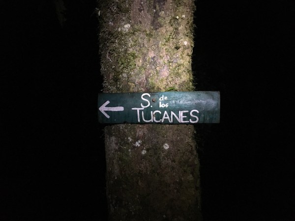
Tucanes Trail (Toucans): Travel Time, 20 minutes.
Total Distance 0.5 km
Elevation minimum 1425 m – maximum 1470 m
The Tucanes trail is a short trail that also leads you in a horseshoe, but takes you down and then up again (opposite of the Quetzales trail). It rests on the downward slope of the mountain that pushes towards the river which slices around the property. It’s lush, filled with low lying plants, and wet. Because of it’s proximity to both the river and a sunny, canopy-less spot on the reserve, you can almost always run into mixed flocks here. Tune in for bird chatter and have fun!
Cascades Trail (waterfalls): Travel Time 15 minutes
Total Distance .4 km
The Cascades trail is a brand new trail that hasn’t even made it on the maps yet. Granted, it’s still a work in progress, but the novel thing about the Cascades trail is that it ends at a waterfall. Definitely wear your boots, though, because where there’s a waterfall there’s water, and where there’s water, there’s mud.
Motmotos Trail (Motmots): Travel Time TBD
Total Distance TBD
Elevation minimum 1357 m – maximum 1455 m
This is probably our favorite trail and we can’t even share it with guests because it’s currently closed (should be opened again within two weeks tops, though!)
When we aren’t in town and aren’t at the lodge, we are most likely at the Motmotos trail working on our main project, a reroute. The motmotos has got problems, y’all, but we love it and it’s recovering.
Motmotos has got it all! Intrigue, daring, innovation, romance (maybe?)! It features the widest variety of micro-ecosystems of the cloud forest. Walking this trail takes you through recovering mudslide zone (no canopy), a fresh water wetland (in the rainy season), a small canyon (you could call it that), a reforestation zone, over a ridge and back down again, along the river (both above and next to), and through lush, green riverside forest. You can never get tired of the scenery on the Motmotos trail because it doesn’t stay the same for long.
It also features views of the mountain tops looming overhead and not one, not two, but three swimming holes. One of which is the most divine place on this planet. Seriously. Stop whatever you are doing and do everything you can to get here and see it. When we first happened upon it, we were both awe-stricken. Our reroute, of course, does not prevent visitors from experiencing the joy of this secluded, waterfall swimming hole.
Since the Motmotos has a variety of transitions through ecosystems (which inevitably means altitudinal ups and downs), it’s one of our harder trails, ranking up there with the Bosque. But like the Bosque, it is so worth it.
The reason it is currently closed is because we are working on rerouting the trail around a mudslide that happened a little over a year ago. The slide completely wiped out a portion of the trail, but c’est la vie in the cloud forest.
We can’t wait for this trail to be finished because when it is, it will be our TOP recommendation to visitors as a must see area of the reserve.
So there you have it. There are our 10 babies we tediously look after. And even though you’re not supposed to have favorites..we do (can you tell?), so maybe you should just visit us and come to your own conclusions?

Thank you! That answered my questions about seeing the ACOR Lek. Sounds too rigorous for me.
LikeLike